Home » Provincial Disaster Profile
Provincial Disaster Profile
Province of Sindh is located in the south-eastern part of Pakistan covering an area of 140,914 Sq. km which is approximately 18% of the total area of the country. The province consists 8.0 million hectares of cultivable land out of 14 million hectares. While remaining part of the province consists of northern hills of Kirthar Range, Thar Desert and the riverine area. Annual average precipitation lies between 6 to 7 inches. The river Indus flows in the middle of the province. There are seasonal streams which become active in the monsoon season that emanate from the Kirthar hill range from west of province and fallout in River Indus and Arabian Sea. Landuse / Landcover (LULC) map of Sindh province is given in Figure 1.1
Geology of Sindh is divisible in three main categories; the mountain ranges of Kirthar, Pab containing a chain of minor hills in the west and Thar Desert in the east and exposure of Karoonjhar Mountains, which is famous for production of Granite. In the north, Sindh is covered by rocks of Laki range extending to Suleiman range while southern most part is encircled by the Arabian Sea. Mostly, rocks are of sedimentary origin of clastic and non-clastic nature that belong to marine, partly marine and fluviatile depositional environments.
DEMOGRAPHY:
According to 2017 census reports of Pakistan, the population of province is 47.89 Million, with a growth rate of 2.41%. Urban and rural population statistics 52.02% and 47.98% respectively, indicate Sindh as most urbanized province of the country. The overall literacy rate of the province is 45.29%.
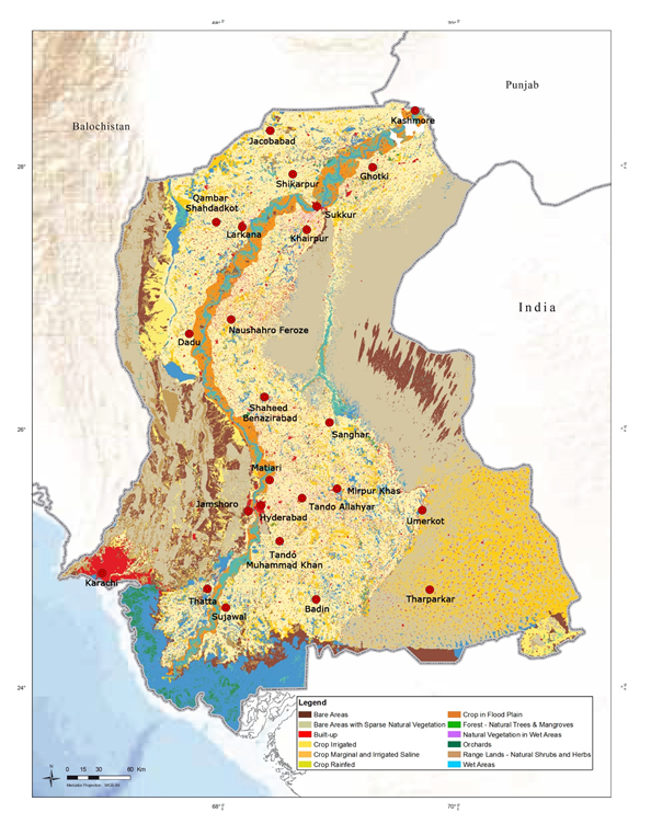
Figure 1.1. LULC Map of Sindh Province
Province is predominantly cosmopolitan where widely spoken languages are Sindhi, Urdu, Punjabi, Pushto, Siraiki, Balochi, Brahui, Rajasthani and Gujarati etc. Majority of the population in Sindh is Muslim. The province is home to Hindus that approximates to 2.0 Million, along with non-Muslim communities of Christians, Paresis or Zoroastrians and Ahmadis.
Sindh has the second largest economy of Pakistan that includes agriculture, livestock, fisheries and industries and services sectors. The province has irrigated agricultural economy that depends almost entirely on the water from Indus River regulated through Guddu, Sukkur and Kotri barrages. Principal crops in Sindh are wheat, rice, cotton, oilseeds and sugarcane.
Most of the industries are concentrated in three major cities Karachi, Hyderabad and Sukkur which produce automobile, textile products, cement, cardboard, chemicals, electric power supplies, heavy machinery and other metal products etc. Sindh preserves rich mineral resources i.e., petrol, gas, coal and granite that contribute substantially to the national economy. There are two modern sea ports in the province namely Karachi Port and Bin Qasim Port.
According to 2017 census reports of Pakistan, there were 5.022 million households in Sindh, with average household size of 6.0 persons and occupancy at 3.3 persons per room. Based on population statistics, the projected number of households is approximately 7.5 million. The overall housing stock comprised 52 percent Katcha (uncemented) houses mostly without proper water and sewerage system, 48 percent cemented or semi-cemented houses. During floods in 2010 and heavy rainfall in years 2011 and 2012, the number of houses that were damaged were 876249, 1503098 and 462725 respectively.
Consequent upon the revival of Commissionerate system, the province is administered through six divisions namely Karachi, Hyderabad, Mirpurkhas, Sukkur and Larkana and Shaheed Benazirabad headed by Commissioners. The divisions are further divided into 30 districts headed by the respective Deputy Commissioners. Karachi, being a metropolitan city and a division as well, is governed in parallel by Karachi Metropolitan Corporation (KMC) and District Municipal Corporations (DMCs). There are 137 Talukas across Sindh province.
Most of the disasters occurring in Sindh are categorized as natural disasters. The most common disasters are floods, cyclone, drought, earthquake and heatwaves. Flood is the most frequent disaster and causes damage to crops, houses, livelihoods, threat to human lives and destruction to civic infrastructure. Monsoon has been assumed to be the common cause of floods. Since 1926, significant floods have been occurred approximately 50 times. The frequency of cyclones is every 3rd or 5th year. Similarly, the earthquake of 2001 inflicted 12 life losses, 45000 houses fully / partially damaged. Earthquake in April 2013 jolted the entire province at 5.5 Richter scale. The province has also experienced severe drought for almost 5 years from 1999-2003. Table 1‑1 shows the relative severity of various disasters occurred in the past.
Table 1‑1. Relative Severity of Various Hazards per District in Sindh
Sr. No. |
District |
Hazard |
Frequency |
Severity |
Years |
1 |
Karachi Central |
Urban Floods |
Monsoon |
Medium |
1966, 1977 |
Heatwave |
Frequently |
High |
Almost Every Year |
||
Earthquake |
Rare |
Low |
2013 |
||
2 |
Karachi East |
Floods |
Monsoon |
Medium |
2017 |
Heatwave |
Frequently |
High |
Almost Every Year |
||
Earthquake |
Rare |
Low |
2013 |
||
3 |
Karachi South |
Urban Floods |
Monsoon |
Medium |
1966, 1977, 2017 |
Heatwave |
Frequently |
High |
2015 |
||
Earthquake |
Rare |
Low |
2013 |
||
4 |
Karachi West |
Urban Floods |
Monsoon |
Medium |
1966, 1977 |
Heatwave |
High |
Almost Every Year |
|||
Earthquake |
Rare |
Low |
2013 |
||
5 |
Korangi |
Urban Floods |
Monsoon |
Medium |
1966, 1977, 2017 |
Heatwave |
Frequently |
High |
2015 – 2017 |
||
Earthquake |
Rare |
Low |
2013 |
||
6 |
Malir |
Floods |
Monsoon |
Medium |
2013, 2014, 2017 |
Heatwave |
Frequently |
High |
Almost Every Year |
||
Earthquake |
Rare |
Low |
2013 |
||
7 |
Hyderabad |
Floods /Rain |
Monsoon |
Medium |
2010,2011, 2012,2014, 2022 |
Droughts |
Rare |
Medium |
1998-2012 |
||
Earthquake |
Rare |
Low |
2011, 2013 |
||
8 |
Badin |
Floods /Rain |
Monsoon |
High |
1970,1975, 1979,1994, 2003,2006, 2011,2012, 2022 |
Droughts |
Rare |
Medium |
1998 to 2012 |
||
Earthquake |
Rare |
Low |
2011,2013 |
||
Cyclone |
Rare |
High |
1964, 1999, 2007 |
||
9 |
Dadu |
Floods /Rain |
Monsoon |
High |
2010, 2022 |
Flood /Rain |
Monsoon |
High |
2011, 2022 |
||
Droughts |
Rare |
Low |
1997-2002 |
||
10 |
Jamshoro |
Riverine Floods |
Monsoon |
High |
2010, 2011, 2022 |
Heavy Rainfall |
Monsoon |
Low |
Heavy Rainfall Monsoon Low 2011, 2012, 2013, 2014, 2022 |
||
Droughts |
Rare |
High |
1999-2002 |
||
Earthquake |
Rare |
Low |
2013 |
||
11 |
Matiari |
Riverine Floods |
Monsoon |
Medium |
2010, 2011, 2022 |
Heavy Rains |
Monsoon |
High |
2011, 2012, 2022 |
||
Earthquake |
Rare |
Low |
2013 |
||
12 |
Sujawal |
Floods/Rain |
Monsoon |
Medium |
2012, 2022 |
Droughts |
Rare |
Medium |
1998 to 2012 |
||
Earthquake |
Rare |
Low |
2011,2013 |
||
13 |
Tando Allahyar |
Flood |
Monsoon |
Medium |
2010, 2011, 2012, 2022 |
Earthquake |
Rare |
Low |
2013 |
||
Heavy Rains |
Monsoon |
Medium |
2010, 2011, 2012 |
||
14 |
Tando Muhammad Khan |
Flood |
Monsoon |
High |
2010, 2022 |
Rain/Flood |
Monsoon |
Medium |
2011, 2022 |
||
15 |
Thatta |
Flood |
Monsoon |
High |
1840,1856, 1874,1942,1946,1948, 1956,1973,1974,1976, 1978,1978,1988,1989, 1992,1994,1995,1996, 1999,2003,2006,2007, 2010, 2011 and 2022 |
Cyclones |
Seasonal |
High |
1964,1993, 1999,2003, |
||
Monsoon rains |
Seasonal |
Medium |
Every year |
||
Tsunami |
Rare |
High |
1945, 2005 |
||
Earthquake |
Rare |
Low |
2001, 2013 |
||
16 |
Mirpur Khas |
Rain/ Flood |
Monsoon |
Medium |
2006-2012, 2022 |
Earthquake |
Rare |
Low |
2013 |
||
17 |
Larkana |
Riverine Floods |
Monsoon |
Medium |
2010, 2011, 2012, 2022 |
Flash Floods |
Seasonal |
Low |
2022 |
||
Earthquake |
Rare |
Low |
|||
18 |
Jacobabad |
Floods |
Monsoon |
Medium |
1942, 2010, 2022 |
Drought |
Rare |
Low |
1999 |
||
Earthquake |
Rare |
Low |
Nil |
||
19 |
Kambar Shahdad Kot |
Flash Flood |
Monsoon |
Medium |
2007, 2010, 2011, 2022 |
Drought |
Infrequent |
Low |
1999-2002 |
||
Earthquake |
Infrequent |
Low |
1935 |
||
20 |
Kashmore |
Floods |
Monsoon |
High |
2003, 2005, 2010, 2022 |
Drought |
Rare |
Low |
2002 |
||
Earthquake |
Rare |
Low |
2001, 2013 |
||
21 |
Shikarpur |
Floods |
Monsoon |
High |
2003,2005, 2010-2012, 2022 |
Earthquake |
Low |
2001 |
|||
22 |
Shaheed Benazirabad |
Riverine Flood |
Monsoon |
Medium |
1973,1976, 1992,2010, 2022 |
Drought |
Frequent |
High |
1999 – 2002 |
||
Earthquake |
Rare |
Very Low |
2013 |
||
23 |
Naushahro Feroz |
Riverine Flood |
Monsoon |
High |
1973,1976,2010,2011,2012,2013, 2022 |
Earthquake |
Rare |
Low |
|||
24 |
Sanghar |
Riverine Flood |
Monsoon |
High |
2006,2007, 2011,2012, 2022 |
Drought |
Common |
Low |
1997-2000, 2013-2014 |
||
Earthquake |
Rare |
Low |
2013 |
||
25 |
Sukkur |
Riverine Flood |
Monsoon |
High |
1973,1976, 2010, 2010, 2022 |
Drought |
Rare |
Low |
1999, 2002 |
||
Earthquake |
Rare |
Low |
|||
26 |
Ghotki |
Riverine Flood |
Monsoon |
High |
2010,2011, 2012, 2022 |
Drought |
Rare |
Low |
2002 |
||
Earthquake |
Rare |
Low |
|||
27 |
Khairpur |
Riverine Flood |
Monsoon |
High |
2010,2011, 2012, 2014, 2022 |
Drought |
Infrequent |
Low |
1999-2002 |
||
Earthquake |
Infrequent |
Low |
|||
28 |
Tharparker |
Drought |
Frequently |
High |
1987-88, 1991-92, 1999,2000,2002-03,2005, |
Earthquake |
Rare |
Low |
1982,2001, 2005,2009 |
||
29 |
Umerkot |
Floods |
Monsoon |
low |
2011, 2012, 2022 |
Drought |
Rare |
Low |
1999- 2002 |
* District information of Karachi West also includes Keamari District.
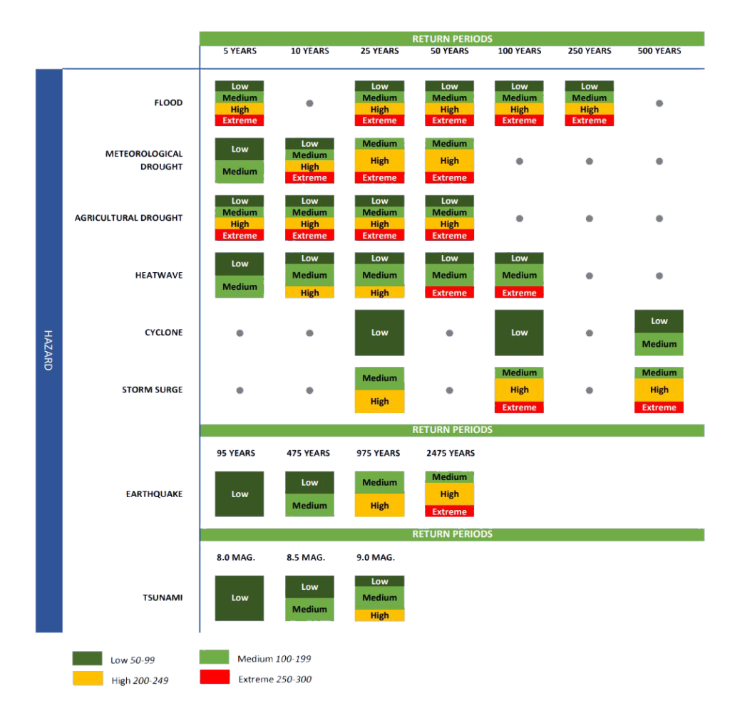
Provincial Risk Matrix